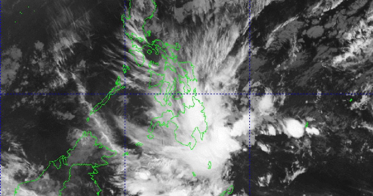
The Philippine Atmospheric Geophysical and Astronomical Services Administration (Pagasa) announced on Tuesday that they are closely monitoring a low pressure area (LPA) located outside the country’s area of responsibility. This weather disturbance, known as an LPA, has the potential to impact the country’s weather patterns in the coming days.
According to Pagasa’s weather specialist, Grace Castaneda, the trough or extension of the LPA is currently affecting several areas in the Philippines. These include Caraga, Davao Region, Camiguin, Misamis Oriental, Bukidnon, and Southern Leyte. Residents in these regions can expect overcast skies with scattered rain showers and thunderstorms over the next 24 hours.
Although there is a possibility for the LPA to develop into a tropical cyclone, Pagasa forecaster Grace Castaneda mentioned that the chances are slim. As of now, the LPA is not expected to enter the country in the coming days. However, Pagasa will continue to closely monitor its development and provide updates as necessary.
For Metro Manila, Luzon, and Visayas, the weather forecast includes partly cloudy to cloudy skies with isolated light rains. This weather condition is primarily due to the northeast monsoon, also known as “amihan,” which is a seasonal wind pattern that brings cool air from the northeast. This weather pattern is typical during the months of November to February and often results in cooler temperatures in these regions.
Meanwhile, the rest of Mindanao is experiencing the effects of the LPA’s extension along with localized thunderstorms. Residents in these areas should be prepared for isolated downpours and thunderstorms, which may prevail throughout the day. It is important to stay updated with the latest weather advisories and take necessary precautions to ensure safety during inclement weather conditions.
It is worth noting that weather patterns and forecasts can vary from one region to another. Local laws, customs, and geography can also influence the impact of weather disturbances. Therefore, it is essential for residents to stay informed through reliable sources, such as Pagasa, and follow any instructions or advisories provided by local authorities.
In conclusion, Pagasa is closely monitoring a low pressure area located outside the Philippines’ area of responsibility. While there is a slim chance for it to develop into a tropical cyclone, the current forecast includes overcast skies with scattered rain showers and thunderstorms in some areas. Metro Manila, Luzon, and Visayas can expect partly cloudy to cloudy skies with isolated light rains due to the northeast monsoon. The rest of Mindanao may experience isolated downpours and thunderstorms. Stay updated with the latest weather advisories and take necessary precautions to ensure safety during inclement weather conditions.


