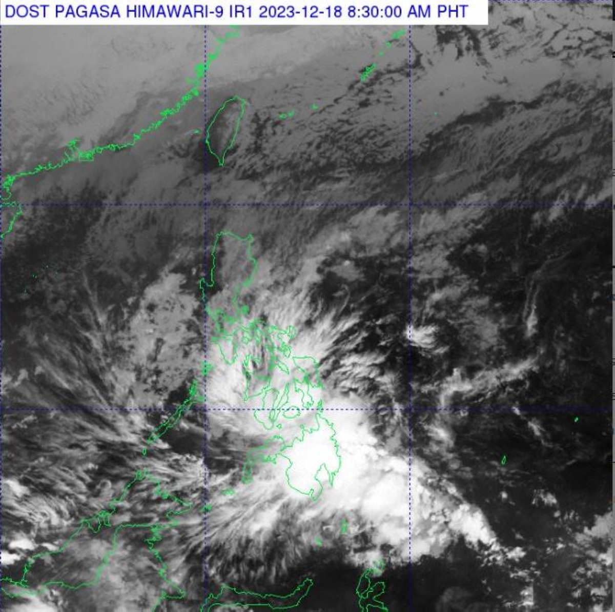
Tropical Depression Kabayan has gained strength, leading the Philippine Atmospheric, Geophysical and Astronomical Services Administration (Pagasa) to issue storm alerts in certain areas of Mindanao. With maximum sustained winds of 65 kilometers per hour near the center and gustiness of up to 80 kph, Kabayan is moving west-northwest at 15 kph.
Under Signal Number 2, the following areas are affected: Dinagat Islands, Surigao del Norte including Siargao and Bucas Grande Islands, Surigao del Sur, the northern portion of Agusan del Norte (Kitcharao, Jabonga, Santiago, City of Cabadbaran, Remedios T. Romualdez, and Tubay), the eastern portion of Agusan del Sur (Trento, Bunawan, San Francisco, Rosario, Prosperidad, City of Bayugan, and Sibagat), and the northern portion of Davao Oriental (Boston and Cateel).
Signal No. 1 has been raised in the southern portion of mainland Palawan (Sofronio, Brooke’s Point, Bataraza, Balabac, Rizal, Quezon, and Narra) and Cagayancillo Islands in Luzon. The same storm alert is in effect for Southern Leyte, Leyte, the southern portion of Samar (Basey, Santa Rita, Marabut, Talalora, Villareal, and Pinabacdao), the southern portion of Eastern Samar (Maydolong, City of Borongan, Quinapondan, Guiuan, Lawaan, Balangiga, Llorente, Giporlos, Salcedo, Balangkayan, General Macarthur, Hernani, and Mercedes), Cebu including Camotes and Bantayan Islands, Bohol, Siquijor, Negros Oriental, Negros Occidental, and Guimaras.
Additionally, Signal No. 1 is in effect for the rest of Agusan del Norte, the rest of Agusan del Sur, the central portion of Davao Oriental (Baganga, Manay, Caraga, Tarragona, Lupon, and Banaybanay), Davao de Oro, Davao del Norte, Davao City, Camiguin, Misamis Oriental, Bukidnon, Misamis Occidental, Lanao del Norte, Lanao del Sur, the northern portion of Maguindanao del Norte (Buldon, Barira, Matanog, Parang, Sultan Kudarat, and Sultan Mastura), the northern portion of Cotabato (Arakan, Carmen, Banisilan, Alamada, President Roxas, Kabacan, Matalam, Antipas, Magpet, Libungan, and Pigkawayan), the northern and central portions of Zamboanga del Norte (Siayan, Sindangan, Jose Dalman, Manukan, Pres. Manuel A. Roxas, Sergio Osmeña Sr., Katipunan, Dipolog City, Polanco, Mutia, Piñan, Dapitan City, Sibutad, La Libertad, Rizal, Siocon, Baliguian, Gutalac, Labason, Kalawit, Tampilisan, Liloy, Salug, Godod, and Bacungan), Zamboanga del Sur, and Zamboanga Sibugay in Mindanao.
Weather specialist Grace Castañeda predicts that Kabayan will likely make landfall as a tropical storm along the coast of Davao Oriental or southern Surigao del Sur sometime today (Monday) before crossing the rugged terrain of Mindanao and emerging over the Sulu Sea between the afternoon and evening.
Meanwhile, Metro Manila and the rest of Luzon can expect partly cloudy to overcast skies with isolated light rains due to the northeast monsoon, locally known as “amihan.”


