

Introduction to the Low Pressure Area
A low pressure area (LPA) is an atmospheric region where the atmospheric pressure is lower than that of the surrounding environment. This phenomenon is crucial in weather forecasting as it often indicates the potential for inclement weather. LPAs typically form due to the rising of warm, moist air, which subsequently cools and condenses to form clouds and precipitation. The dynamics of these systems can lead to the development of more intense weather conditions, such as tropical depressions, tropical storms, or even typhoons, depending on various atmospheric factors.
The formation of an LPA is a fundamental aspect of meteorology, as it can set the stage for significant weather events. When an LPA forms, it can undergo various stages of development. Initially, it may appear as a cluster of thunderstorms. If the environmental conditions are favorable, including warm sea surface temperatures and low vertical wind shear, the LPA can intensify. This intensification can lead to the formation of a tropical depression, which is characterized by organized convection and a well-defined circulation. Further strengthening can transform the system into a tropical storm and potentially a typhoon, depending on the sustained wind speeds achieved.
Recently, an LPA has been identified east of Mindanao, one of the major islands in the southern Philippines. This specific weather system has garnered attention due to its potential impact on the region. Meteorologists are closely monitoring this LPA as it has the potential to bring heavy rainfall, strong winds, and other adverse weather conditions to parts of the Philippines. The presence of such an LPA near Mindanao highlights the importance of vigilant weather forecasting and preparedness, as these systems can significantly affect local communities and infrastructure.
Understanding the formation and progression of LPAs is essential for effective weather forecasting and disaster preparedness. As the current LPA near Mindanao evolves, staying informed through reliable weather updates is crucial for minimizing risks and ensuring the safety of affected populations.
Current Location and Forecasted Path
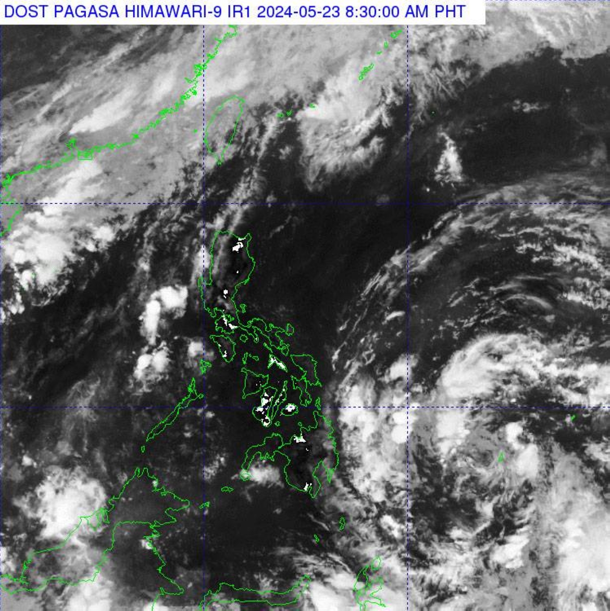
As of the latest meteorological data, the Low Pressure Area (LPA) is currently situated approximately 1,080 kilometers east of southeastern Mindanao. This area of atmospheric disturbance has been closely monitored due to its potential impact on the weather patterns in the Philippines. The LPA is expected to move westward in the coming days, with projections indicating that it will enter the Philippine Area of Responsibility (PAR) soon.
Once the LPA enters the PAR, it is forecasted to traverse through Eastern Visayas and Eastern Luzon. During this period, the LPA’s trajectory will be critical in determining the specific regions that may experience increased rainfall and potential weather disturbances. Meteorologists are employing advanced tracking technologies to predict the exact path and intensity of the LPA, providing timely updates to ensure preparedness and minimize risks.
The anticipated movement of the LPA through Eastern Visayas and Eastern Luzon suggests that these regions should prepare for possible changes in weather conditions, including heavy rainfall, strong winds, and potential flooding. Local government units and disaster response teams are advised to remain vigilant and ready to implement contingency plans to protect communities and mitigate the impact of adverse weather.
For a visual representation, a map illustrating the current location of the LPA and its forecasted path is highly recommended. This visual aid can enhance understanding and help residents and officials in the affected areas to better grasp the potential impact and necessary precautions. Continuous monitoring and updated weather advisories will play a crucial role in ensuring that the population remains informed and prepared.
The potential for the Low Pressure Area (LPA) near Mindanao to develop into a tropical depression is a significant concern. If it intensifies to this stage, it will be designated as “Aghon,” following the naming conventions set by the Philippine Atmospheric, Geophysical and Astronomical Services Administration (PAGASA). These names are predetermined and follow a rotating list, ensuring that each tropical storm or depression is uniquely identified, which aids in effective communication and public awareness.
For an LPA to be classified as a tropical depression, it must meet specific meteorological criteria, including sustained wind speeds of 30 to 60 kilometers per hour near the center. Once these conditions are met, PAGASA assigns a name to the system, which then becomes a reference point for all subsequent communications and warnings. This practice is crucial for clarity, especially during peak typhoon seasons when multiple weather systems may be active simultaneously.
Monitoring the development of such weather systems is essential for public safety and preparedness. The transition from an LPA to a tropical depression can bring about significant changes in weather patterns, including increased rainfall, stronger winds, and potential flooding. These changes necessitate timely updates from meteorological agencies and proactive measures from local government units and communities. Preparedness plans often include preemptive evacuations, securing properties, and stockpiling essential supplies.
Understanding the criteria and the significance of naming tropical depressions helps in appreciating the measures taken by meteorological authorities. It underscores the importance of vigilance and readiness among the populace, as timely and accurate information can mitigate the adverse impacts of such weather disturbances. As the LPA near Mindanao continues to evolve, continuous monitoring and adherence to advisories will be crucial in ensuring the safety and well-being of the affected regions.
Role of PAGASA in Weather Monitoring
The Philippine Atmospheric, Geophysical, and Astronomical Services Administration (PAGASA) plays a crucial role in monitoring and forecasting weather conditions within the Philippines. As the national weather bureau, PAGASA is responsible for providing accurate and timely weather information to ensure the safety and preparedness of the public. Utilizing advanced tools and methodologies, PAGASA tracks weather disturbances such as the low pressure area near Mindanao, providing essential warnings and updates.
PAGASA employs a range of sophisticated technologies to monitor weather patterns. These include weather radars, satellites, and automated weather stations strategically located throughout the country. The use of Doppler radar systems enables PAGASA to detect precipitation, wind speed, and direction, which are vital for understanding the development and movement of weather systems. Satellite imagery provides a broader perspective, allowing meteorologists to observe cloud formations, track storm systems, and assess their potential impact.
In addition to these tools, PAGASA utilizes numerical weather prediction models that integrate data from various sources to generate forecasts. These models simulate the atmosphere’s behavior, helping meteorologists predict the path and intensity of weather disturbances. By analyzing these models alongside real-time data, PAGASA can issue weather advisories, warnings, and bulletins, which are disseminated through various channels such as television, radio, and social media.
Accurate weather forecasting is critical in mitigating the impacts of severe weather events. By providing reliable information, PAGASA enables government agencies, local authorities, and communities to implement necessary precautions and response measures. This proactive approach helps to minimize the loss of life, reduce property damage, and ensure public safety. Moreover, timely weather updates assist in planning and decision-making processes for sectors such as agriculture, aviation, and maritime operations.
In essence, PAGASA’s role in weather monitoring and forecasting is indispensable in safeguarding the Philippines from the adverse effects of weather disturbances. By leveraging advanced technologies and methodologies, PAGASA continues to enhance its capabilities in delivering accurate and timely weather information to the public.
Weather Patterns and Seasonal Context
The Philippines, located in the tropical region, experiences varying weather patterns influenced by several atmospheric phenomena. During this time of year, the influence of the easterlies is particularly pronounced. Easterlies are trade winds that blow from the east to the west and are a dominant weather feature in the region. These winds bring with them hot and humid conditions, which are characteristic of the current season.
The presence of easterlies typically results in elevated temperatures across the archipelago. Residents often experience sweltering heat during the day, which is occasionally tempered by isolated rain showers or thunderstorms. These rain showers are usually short-lived but can be intense, providing temporary relief from the heat. Thunderstorms, while also sporadic, can bring about sudden and heavy downpours, sometimes accompanied by lightning and strong winds.
Such weather variability is normal for this period, known as the dry season or “tag-init” in the local vernacular. It spans from March to May and is marked by hot and dry conditions. However, the transition period between the dry and rainy seasons can introduce more frequent weather disturbances, including the formation of low-pressure areas.
In the context of Mindanao, the current low-pressure area, while not uncommon, requires careful monitoring. Low-pressure systems can develop into more significant weather events, such as tropical depressions or storms. Therefore, understanding the typical weather patterns and seasonal context helps residents and authorities anticipate and prepare for these changes.
Overall, the influence of the easterlies, coupled with the inherent variability of the season, shapes the current weather landscape in the Philippines. Residents should stay informed about weather updates to manage the impacts of these fluctuating conditions effectively.
Impacts on Daily Life and Preparations
The formation of a low-pressure area (LPA) near Mindanao can significantly affect daily life in the region. Residents may experience heavy rains, flooding, and strong winds, which can disrupt normal activities and pose various hazards. Understanding these potential impacts and taking proactive measures can help mitigate the risks associated with such weather phenomena.
One of the immediate impacts of an LPA is the potential for heavy rainfall. Prolonged periods of rain can lead to flooding, especially in low-lying and coastal areas. This can result in road closures, transportation delays, and even evacuations in severe cases. Additionally, strong winds associated with tropical depressions can cause property damage, power outages, and fallen trees, further complicating daily routines.
To prepare for these eventualities, residents should focus on assembling an emergency kit that includes essential items such as non-perishable food, water, medications, flashlights, batteries, and important documents. This kit should be easily accessible in case of sudden evacuations. It’s also advisable to have a battery-operated radio to stay informed about weather updates and emergency instructions from reliable sources.
Securing property is another crucial step in preparation. Ensure that your home is fortified against strong winds by checking the stability of roofs, windows, and doors. Trim trees and remove any outdoor items that could become projectiles during a storm. Additionally, make sure drainage systems are clear to prevent water accumulation and potential flooding.
Staying informed is vital during such weather events. Regularly monitor weather forecasts and advisories from authoritative sources such as the Philippine Atmospheric, Geophysical and Astronomical Services Administration (PAGASA). Local government units and emergency services also provide timely updates and instructions that can help residents make informed decisions.
By understanding the potential impacts of an LPA and taking appropriate preparatory measures, residents can better protect themselves and their properties. Proactive planning and the use of reliable information sources are key to minimizing the disruptions and dangers posed by adverse weather conditions.
Low-pressure areas (LPAs) are meteorological phenomena that occur globally, influencing weather patterns and often leading to severe weather conditions. In the context of the Philippines, particularly near Mindanao, understanding LPAs is crucial due to the region’s vulnerability to tropical cyclones. To provide a comprehensive perspective, it’s valuable to compare these systems with similar weather patterns in other parts of the world and examine the local responses influenced by regional laws, customs, and infrastructure.
Comparative Analysis with International Weather Systems
In the United States, LPAs often develop into tropical storms or hurricanes, particularly in the Atlantic and Gulf of Mexico regions. The National Hurricane Center (NHC) utilizes advanced satellite technology and extensive meteorological research to predict and track these systems. Similarly, in Japan, low-pressure systems frequently lead to typhoons. The country’s Meteorological Agency employs sophisticated early warning systems and has well-established evacuation protocols to mitigate the impact.
In contrast, the Philippines, with its location in the Pacific typhoon belt, faces a distinct set of challenges. Local laws and customs play a significant role in shaping the response to LPAs. The Philippine Atmospheric, Geophysical and Astronomical Services Administration (PAGASA) is the primary agency responsible for monitoring and issuing warnings. However, the effectiveness of these warnings can be constrained by regional infrastructure limitations and the geographical spread of the archipelago.
Moreover, local customs and socioeconomic factors influence the preparedness and response strategies. For instance, communities in coastal areas near Mindanao often rely on traditional knowledge and communal decision-making processes to anticipate and respond to weather events. While this can be beneficial in leveraging local expertise, it may sometimes conflict with formal evacuation orders or scientific advisories issued by PAGASA.
Internationally, countries like the United States and Japan have extensive disaster preparedness programs, which include regular drills, stringent building codes, and substantial investment in resilient infrastructure. These measures significantly mitigate the impact of LPAs and similar weather systems. In contrast, the Philippines, with its diverse and often challenging terrain, faces hurdles in implementing similar widespread measures, although there are ongoing efforts to enhance resilience through community-based disaster risk reduction programs and international collaboration.
By examining the approaches of other nations, the Philippines can glean valuable insights into improving its response to LPAs. Enhancing infrastructure, investing in advanced forecasting technology, and fostering a culture of preparedness can collectively fortify the nation against the adverse effects of these weather systems.
Conclusion and Future Monitoring
The low pressure area near Mindanao holds significant implications for the Philippines, as discussed in various sections of this blog post. Understanding the dynamics of low pressure areas and their potential to escalate into severe weather systems is crucial for safeguarding lives and property. The insights provided by PAGASA, the Philippines’ foremost meteorological agency, play a pivotal role in keeping the public informed and prepared.
Staying updated with the latest weather forecasts from PAGASA is not just advisable but essential. Accurate and timely information enables individuals and communities to take proactive measures, whether that involves securing property, preparing emergency kits, or planning evacuation routes. The importance of community awareness cannot be overstated; informed communities are resilient communities, capable of facing natural disasters with greater preparedness and confidence.
Moreover, the ongoing need for monitoring weather patterns remains a priority. As climate change continues to impact weather systems globally, the frequency and intensity of low pressure areas and other severe weather phenomena may increase. This necessitates a robust and continuous effort in weather monitoring, research, and community education. Through sustained vigilance and the dissemination of reliable information, the collective resilience against natural disasters can be significantly enhanced.
In conclusion, the low pressure area near Mindanao serves as a reminder of the persistent and evolving challenges posed by natural weather systems. By remaining informed through agencies like PAGASA and fostering a culture of preparedness, the Philippines can better navigate the uncertainties of its meteorological landscape. Community awareness and proactive measures are key components in building a resilient nation, ready to face the adversities brought about by severe weather conditions.